Ireland feels shockwaves from magnitude 7.7 earthquake in Myanmar

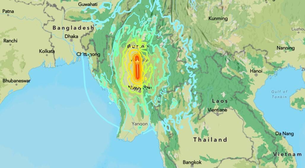
A map of the epicentre and intensity of Friday's earthquake in Myanmar. The Irish National Seismic Network says that, tectonically, Friday's earthquake is likely to have occurred as the result of a strike-slip faulting between the India and Eurasia plates. Picture: US Geological Survey
The devastating earthquake which struck Myanmar and Thailand on Friday was so powerful that it was picked up by seismometers here in Ireland.
The magnitude 7.7 quake struck about 17km northwest of Mandalay, Myanmar's second-largest city at around 12.50am local time, 6.21am Irish time. A second quake, with a magnitude of 6.4 shook the area 12 minutes later.
The earthquake has killed more than 150 people as well as destroying buildings, a bridge and a dam in both countries.
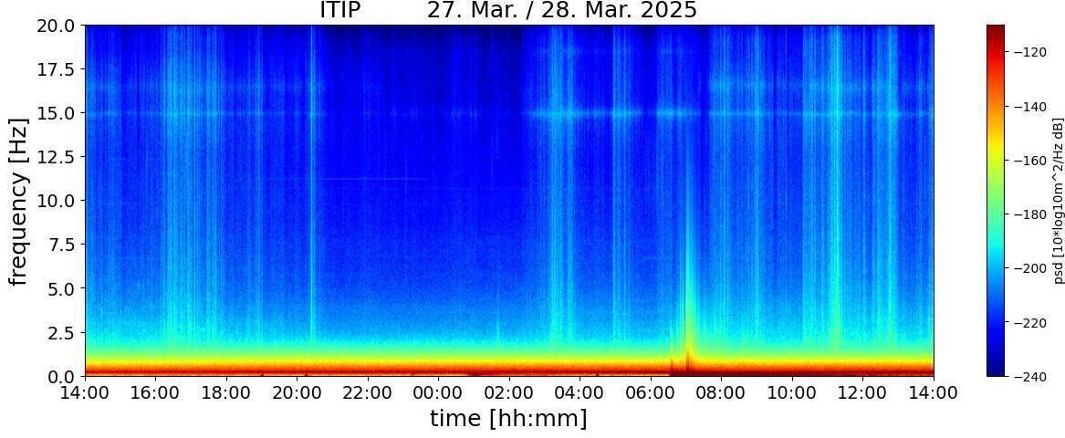
Just over half an hour after the initial quake, a shock wave from it was picked up by Irish National Seismic monitors in Tipperary and Mayo. It was also recorded by other seismic stations across the country, including in Louth, Inch Island in Donegal, Wexford, Mitchelstown Cave, Galway, and West Cork.
According to the Irish National Seismic Network (INSN), such was the strength of the quake, seismographs in Valentia in Kerry and in Dublin also recorded sound wave readings over a 15-minute period from just before 7am this morning.

The INSN says that, tectonically, Friday's earthquake is likely to have occurred as a result of a strike-slip faulting between the India and Eurasia tectonic plates.
The region has experienced similar large strike-slip earthquakes before, with six quakes of a magnitude of 7.0 or higher recorded within about 250km of Friday's quake since 1900.
The most recent of these was a magnitude 7.0 quake in January 1990. A magnitude 7.9 earthquake occurred south of today’s quake in February 1912.
At least 144 people were killed in Myanmar, where photos and video from two hard-hit cities showed extensive damage. At least eight died in the Thai capital, where a high-rise building under construction collapsed.
Thailand’s defence minister Phumtham Wechayachai earlier said 90 people were missing at the site where the building collapsed.
"This is a very serious earthquake event," said Associate Professor in Structural Engineering at University College Dublin, Dr Daniel McCrum.

"The United States Geological Survey (USGS) has issued a red alert for shaking-related fatalities and economic losses. The USGS expect a high level of casualties and extensive damage with the disaster likely to be widespread," he said.
"Such significant earthquakes typically require an international response."
Dr McCrum said the majority of people living in the affected areas live in building structures which have not been designed to resist earthquake.
"Reports are already coming in highlighting several building collapses. A significant amount of housing still standing after the earthquake may be unsafe for people to move back into, and services such as water and electricity will be significantly affected," he said.


